
Upload your flight logs
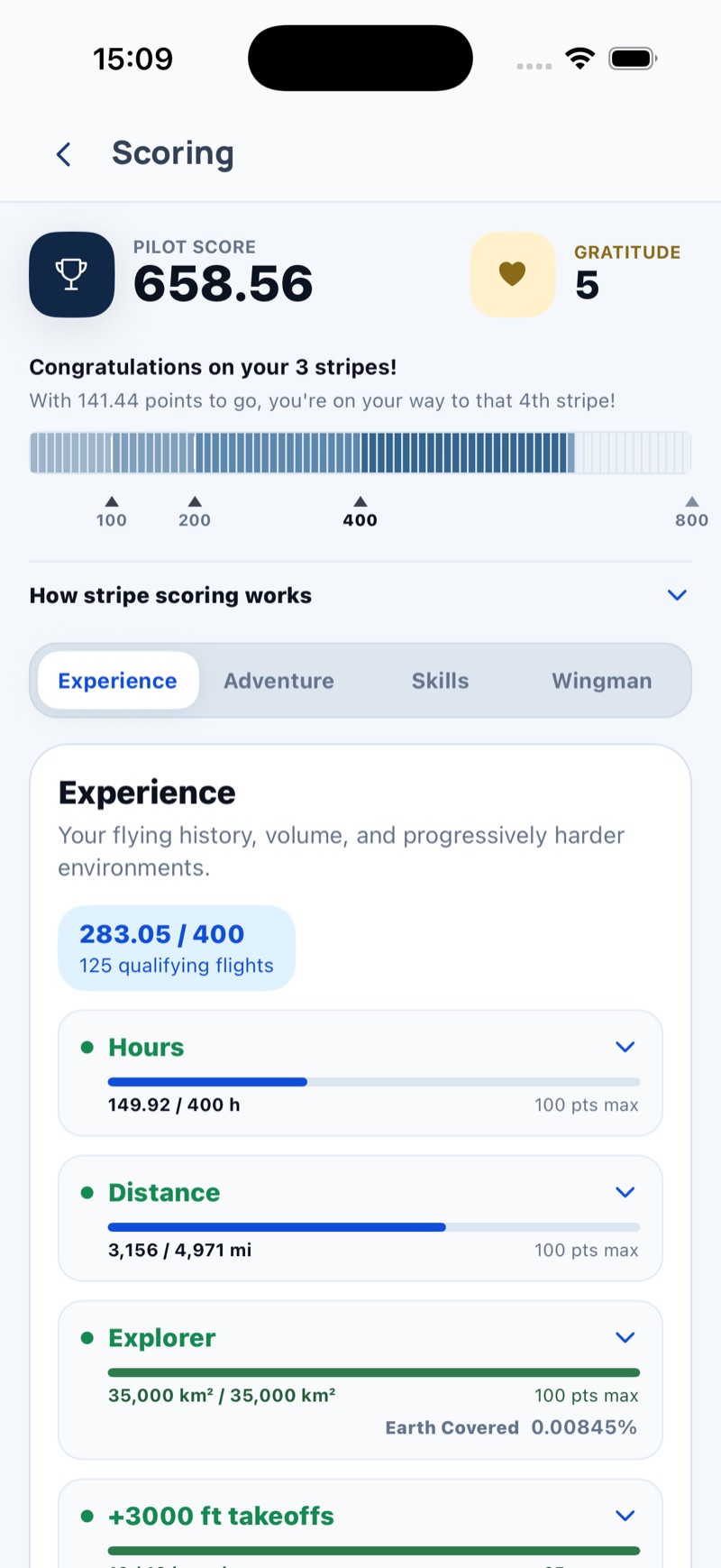
SkyTribe will give you scores in 4 different areas and across 16 different scoring criteria.


Connect, inspire, develop
Record your flights in SkyTribe or bring them in from the apps and devices you already use. Understand your flying, share what you choose, and climb the ladder as a paramotor pilot.
Free to use. iOS first. Coming shortly on the App Store.
Not the same thing. Instead of getting lost along the confusing Dunning–Kruger confidence line, SkyTribe can give you the most accurate feedback on your current skill and experience level.
SkyTribe will give you scores in 4 different areas and across 16 different scoring criteria.
Hours, distance, exploration, and high-elevation takeoffs.
Mountains, cross-country flights, new countries, and ground nobody has flown.
How powerful, precise, and smooth are your wingovers, barrel rolls, swoops, and slalom skills?
Is it possible to measure being a good person? Yes, it is!
Some pilots think that once they finish training, they are done. Some pilots believe that’s it, and then they stay stuck at the same skill and experience level for a few years until the thrill of paramotoring slowly decays. Never stop learning!
You don’t know what you don’t know. Now, with SkyTribe, you know. SkyTribe’s scoring system will show you your best potential to grow your skills and experience as a pilot. Progress slowly but steadily and safely to earn your golden pilot stripes as public recognition of your achievements.
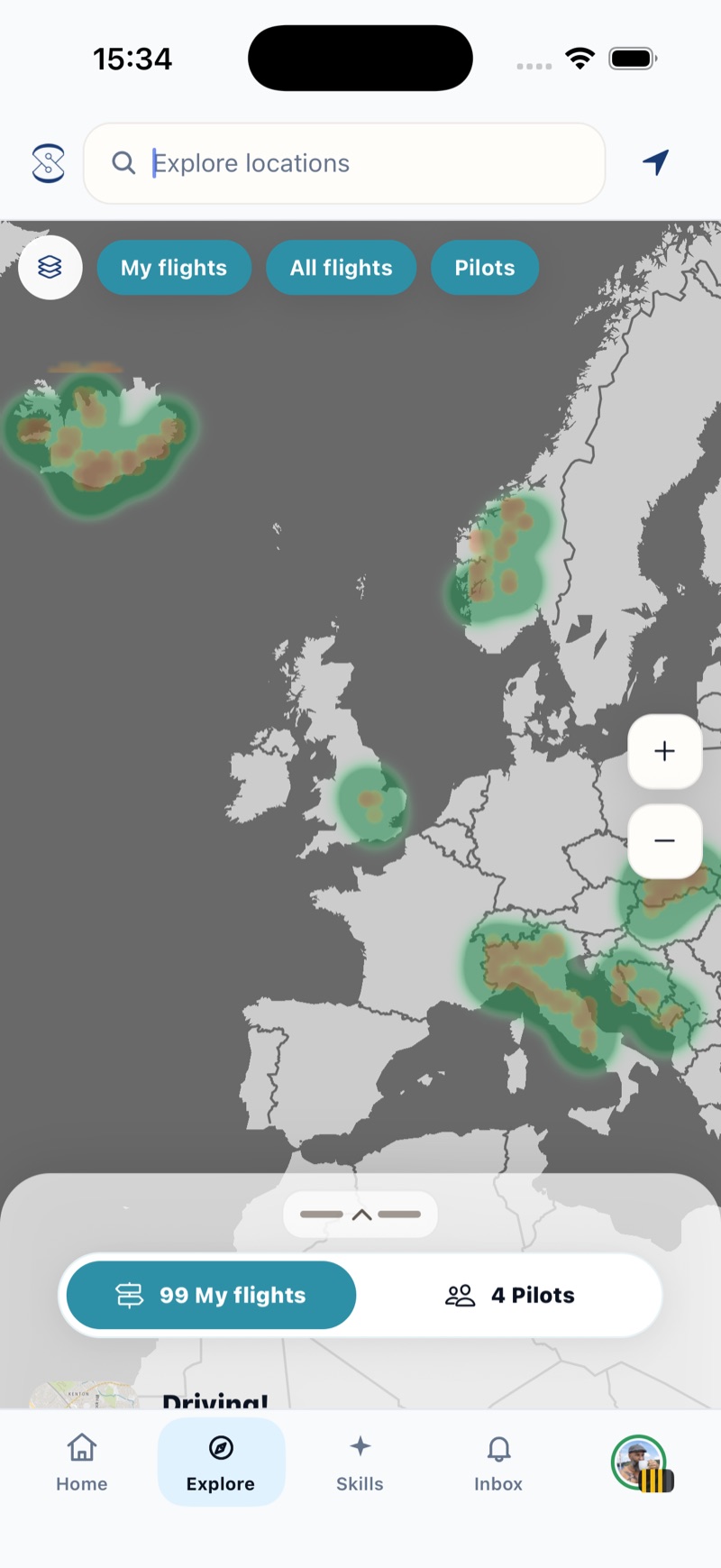
SkyTribe highlights the places you have flown only to show you the places still to explore. Paint the Earth with your color, and never fly to the same places again. Challenge yourself to fly some mountains. Challenge yourself to actually fly somewhere, camp overnight, and feel like a true hero.
Traveling to a new place with your paramotor? The heatmap will show you the best spots. The places flown most often will glow hot red, so you know there must be something interesting there. Now, you will never miss a thing simply because you did not know about it.
How about flying places no one has ever flown before? Oh, the Earth is huge, and there is still so much to explore. How would it feel to know you are the first one ever to fly there?
You may feel like you are ripping it. You may feel like you are ready for a more advanced maneuver or a smaller, spicier glider. But how would you know?
Record your wingovers with your phone, and SkyTribe’s advanced data analysis will give you usable and actionable tips on how to improve.
And you will likely find out that there is still plenty of room for improvement. And you will likely find out that you have not exploited the full potential of the glider you own right now.
If it saves you the cost of a new glider (or saves a life), it was worth it.
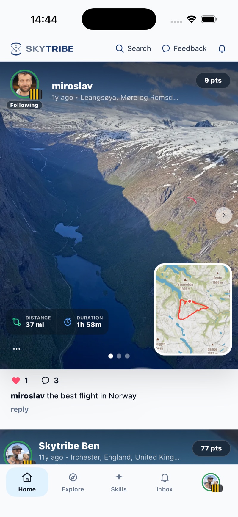
The feed is real flights from real pilots: a fjord in Norway, a first cross country, a long day over the mountains. Photos and clips ride along with each flight, so you see the flying, not just the numbers.
Every card is a flight someone flew, with the track, the numbers and their stripes beside their name.
Add photos and video clips up to 15 seconds to your flights. The fjord from the seat, the launch field at sunrise, the landing that went to plan.
Your feed leans toward the pilots you follow, your close friends and flying near you. Follow the ones who stretch your idea of what a paramotor can do.
Find them on SkyTribe and get in touch instantly! SkyTribe happens to be the place to find anyone and everyone.
Connect with pilots who already know the area.
Find the places you would otherwise miss.
Learn from the pilots who understand the local area.
Find them on SkyTribe and start the conversation.
It’s very likely that someone has had the same problem and someone else has had the answer. We wonder how many times the same questions have been asked and answered. Those answers are somewhere out there in the online world, and they get lost and forgotten. What a waste!
AskTribe brings all the questions and answers to one place and keeps them! Ask anything, and you will likely find the answer instantly. And if not, the good people in SkyTribe will help. This way, the community’s know-how grows over time.
Record directly in SkyTribe or bring flights in from wherever you already log them, so every route gets a title and starts counting toward your stripes.
Export FIT, GPX or IGC files from Garmin Connect and share them into SkyTribe for replay, terrain and scoring.
Share any .igc, .gpx or .fit file from your favourite flying app, zipped Garmin originals included.
Link your xcBrain device with a code from the app.
The same flight from two sources is spotted and kept once. Every flight gets a title from where and when you flew.
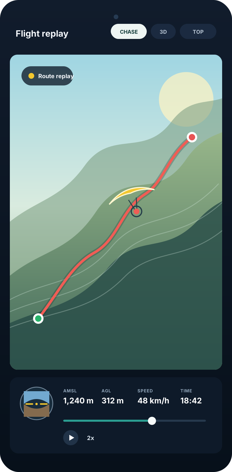
Every flight replays in 3D over an elevation-based terrain view. It is a nice way to relive a day and an easy way to show a friend what the route felt like.
Elevation data shapes the ground beneath your route, so climbs, valleys and ridges have useful context.
Follow your own wing from behind, with your height above ground as you go.
Distance, duration, altitude, speed and climb, computed for every flight.
You do not need to publish your flights in order to get them scored. You do not need to publish your flights under your name in order to contribute to the heatmap. All this teamwork can be accomplished without compromising your privacy.
Only your last 10 flights and your top 10 flights are public, and only if you decide to make them so. Or you can restrict visibility to your close friends only or hide them entirely.
You do not need to publish your flights under your name in order to contribute to the heatmap.
The first and last five minutes of your flights are hidden to protect your sensitive LZ.
Altitudes below 1,000 ft AGL are hidden in case you feel rebellious and decide to lose yourself.
You may want your friends to see the cool stuff you are doing (we are ego-driven beings, even if it is hard to admit).
Straight answers, no small print.
Yes. SkyTribe is free to use.
Yes. Record a flight directly in SkyTribe or import an .igc, .gpx, .fit or zipped Garmin file. SkyTribe brings those flights together to help you understand your flying, share what you choose with the tribe and develop your capabilities.
Record directly in SkyTribe or share any .igc, .gpx or .fit file into the app, including zipped Garmin originals. If the same flight arrives twice, one copy is kept.
Your stripes are one number, 0 to 4, from your total score across Experience, Adventure, Skills and Wingman. Early flying scores fastest and every metric has a ceiling: the first hour is worth four times the four hundredth, and the first new country four times the last. Each stripe takes double the points of the last, so a fourth stripe in practice needs more than one way to climb. That is why four-stripe pilots are all-rounders. The Scoring screen shows exactly where you stand.
Climb to 2,500 ft (about 760 m) above ground for wingovers, or 2,000 ft (600 m) for the other sessions, and press Start. Secure your phone, glide straight, then fly your sequence when told. Glide straight again above 1,000 ft (300 m) to finish, or land and stop for swoops. Wingovers are scored 0 to 100.
Open their profile and thank them for mentorship, support or inspiration. It shows on their Scoring screen as gratitude, and it is how the tribe recognises the pilots who bring others along.
You decide. Only your last 10 flights and your top 10 flights are public, and only if you decide to make them so. You can restrict visibility to close friends or hide flights entirely. The first and last five minutes and altitudes below 1,000 ft AGL are hidden.
SkyTribe is built for paramotor pilots. The ladder, the acro analyser and the community are all designed around powered flight.
SkyTribe is an iPhone app.
Both, plus an Aviation preset. You can also set distance, altitude, speed, vertical speed and area one by one.
Yes. Add your wings and paramotors, props included, and tag them on each flight.
Never stop learning.
Bring your flights together, see where the tribe flies, and start climbing. SkyTribe is free, and full of surprises.
Free to use. iOS first. Coming shortly on the App Store.